What to see

One project, dozens of possibilities

Among the tasks of the Cape Ortegal Geopark Project is to design a complete catalog of geological resources and routes that cater to different audiences: schoolchildren, specialists in the field and visitors with different levels of knowledge. Audiences who should be provided with a different offer -and adapted to their profile- that is based on a knowledge of the history of the Earth combined with other aspects, such as gastronomy, culture, heritage or even cultural and sporting events. 

The project is aimed at the design of a complete catalog of geological resources and routes that cater to different audiences: schoolchildren, people specializing in the subject and visitors with different levels of knowledge.

The town councils and other public and private entities that support the project have been working for some time on the enhancement of the territory with websites and information covering both the main points of interest and the services of all kinds associated with them.

Any geopark project is structured on three main elements related to each other and with the same specific weight: an abiotic base -the rocks and formations that make it unique-, a biotic layer -the life settled on the abiotic base- and, thirdly, the facet related to all manifestations of culture: civil and religious architectural heritage, traditions, gastronomy, history, cultural expressions, etc.

The Cape Ortegal Geopark Project is now developing the first section of this “abc”, that of the knowledge of the geological wealth as a support for the other two, which have been investigated, protected and promoted as a tourist attraction for decades.

Protected areas network in the project area (Source: IET, Xunta de Galicia)

The entire coastal area, from Valdoviño to Ortigueira, has some degree of protection at European level, with declarations of Special Areas of Conservation, Areas of Special Natural Value or Special Protection Areas for Birds. In addition, in the southern half of the project delimitation there is also the ZEC-ZEVN Xubia-Castro area and between Ortigueira and Cerdido we find the ZEC-ZEVN Ortigueira-Mera axis. Natural areas characterized by flora and fauna mainly associated with coastal landscapes, intertidal movements and Atlantic forests, with some examples of animal and plant endemisms. 

Ortigueira wetland with San Vicente Island in the background.

A land of unique experiences

In this geographical context, the population of the territory has evolved, adapting to the environment and taking advantage of the technology available at any given time. Throughout the project area we have evidence of human activities for more than 6,000 years, as evidenced by the Bronze Age burials scattered from O Forgoselo to the northern coastal boundary, followed by important references of the Iron Age and castrexas cultures. There is also evidence of Romanization and, above all, an important collection of heritage elements that began to gather in the Middle Ages – castles, monasteries, churches, crosses, anthropomorphic tombs, etc. – to which are added, precisely, examples of the evolution of the use of resources linked to the land and the sea: water and wind mills, granaries, ports, farmhouses, etc. And, in a higher substrate, all the immaterial culture associated with traditions and popular knowledge, among which the sanctuary of San Andrés de Teixido stands out as the end of a millenary spiritual path, assimilated by Christianity, which today is the second in importance in Galicia in terms of visitors, only surpassed by the various pilgrimage routes to Santiago de Compostela. The culture of the whole area is also expressed through its own gastronomy related to local products of the highest quality -fish, seafood, meat, vegetables, dairy products, honey…- which offer in this area the best slow food experiences, with all that this concept implies in terms of flavors and commitment to sustainable food production in social and environmental terms. If we combine a unique natural and historical heritage with an exceptional gastronomy -supported by a wide network of restaurants and points of sale- we will have two of the keys that explain why this area has become in recent years one of the major tourist destinations in the north of the Peninsula. But there is more, since the offer of routes and services to discover the territory is complemented by a wide range of events that connect directly with tradition or are new initiatives: the Festival of the Celtic World of Ortigueira, the Festival Irmandiño and the fairs of 11th and 23th in Moeche, the maritime processions of the seafaring towns -Cariño, Cedeira and Ortigueira-, the recovery of the Samaín in Cedeira and of the “mallas” -cereal threshing- in Cerdido, the international surfing event at the Pantín Classic fo Valdoviño, the Rural Fair of San Sadurniño. ..
Castelo de Moeche
Moeche Castle
Ortigueira Festival

And geology too...

All these layers -natural and historical heritage, gastronomy, culture, etc.- are combined in a tourist offer promoted from each municipality and from supramunicipal bodies, such as the Mancomunidad de Concellos de la Comarca de Ferrol, responsible for the Geodestino Ferrolterra Rías Altas that allows to configure stays of several days according to preferences. 

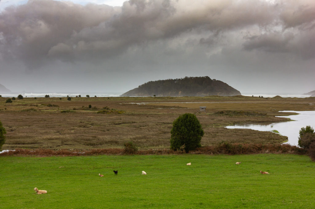
Now to all these promotional actions of the territory is added a new layer, geotourism, conceived as the discovery of the area starting from where it all began, from a unique geology that has shaped landscapes and ways of life.

For this reason, the project has conceived a possible organization of this offer, grouping the main elements by zones. The result is ten individual cards with a description of the most outstanding geological resources, which can be combined with the rest of the heritage and cultural proposals, approaching each destination on your own – except in cases of special difficulty – or as part of guided tours. In addition, due to the proximity of some of the geological landmarks, it is even possible to plan one or two destinations each day.

A journey into the interior of the Earth

© Mancomunidade de Concellos da Comarca de Ferrol

Follow us on social networks!